Flabbergasted. Astonished. Respectful...even at time disbelieving. That was how I felt after reading 'Unsurpassed' the incredible story of Tommy Godwin...a long distance cyclist who has given new definition to the word 'endurance'.
The year was 1939. A 27 year old amateur cyclist from Stoke on Trent pedaled away from home to set about challenging a cycling magazine competition with a challenge to see who could cycle the farthest distance in a calender year, under club riding rules. Now here is the crazy part. 1 year later, Tommy had racked up a thigh screaming, buttock blistering 75,000 miles (120,00km). Yes, you read that correctly...an average of 205 miles per day, times 365. This was on a heavy steal bike, without modern nutrition (and in fact through war time Britain and rationing) and through a notoriously nasty winter.
To put this into perspective: A fit and trained cyclist can do a 100 miles in a day and be pretty much OK the next day with good nutrition and a good nights sleep. 200 miles in a day is a whole new level that heads into Audax territory - and you just don't hear of riders being able to sustain anything close to that level of distance for weeks...let alone months...let alone a year.
At his peak in June, Tommy knocked out the following distances over consecutive days...in miles:
258
295
361
291
231
I just can't imaging riding 361 miles in a day, even with fresh legs! Astonishingly...at the end of his 1 year completely smashing all other records...in true Forrest Gump style but without the Hollywood script writers, Tommy kept on riding until he hit day 500, and with 100,000 miles done, and only 1 rest day!!
You would think after a ride like that he'd have earned a jolly good lie down - but 3 weeks later the war had caught up with Tommy and he was conscripted into the Army. Problem for the Army was, Tommy could still not walk properly yet!
The story of Tommy Godwin has further endearing quality's too because of his humble upbringing, complete lack of fame and ego...and for those who have pushed themselves physically on long rides can appreciate, the incredible mental strength and bloody mindedness he must have had to keep going. Really inspiring stuff...some great photos and information here if you are interested in his story.
His record still stands.
A blog about cycling...especially the long distance stuff
Monday, 10 November 2014
Sunday, 13 April 2014
Melbourne to Sydney - Tour Summary
A trip summary with information here helpful to anyone else planning something similar...
Basic Plan
Cycle from Melbourne to Sydney via the southern coastal route through Gippsland then up the NSW coast, avoiding the Princess Highway where possible. Most of my route is on road, though about 150 km all up on dirt roads (Rail Trails in particular, which are great for riding).
Day 1: Frankston to Kilcunda / Route Map / Distance - 93 km / + 393m
Day 2: Kilcunda to Yarram / Route Map / Distance - 129 km / + 721m
Day 3: Yarram to Lake Wellington / Route Map / Distance - 147 km / + 553m
Day 4: Lake Wellington to Orbost / Route Map / Distance - 141 km / +944m
Day 5: Orbost to Cann River / Route Map / Distance - 75 km / + 1144m
Day 6: Cann River to Eden / Route Map / Distance - 111 km / + 1452m
Day 7: Rest Day
Day 8: Eden to Bermegui / Route Map / Distance - 100 km / +1600m
Day 9: Bermegui to Surf Beach / Route Map / Distance - 120 km / + 1406m
Day 10: Surf Beach to Ulladulla / Route Map / Distance - 81 km / + 975m
Day 11: Ulladulla to Shoalhaven / Route Map / Distance - 102 km / +864m
Day 12: Shoalhaven to Wollongong / Route Map / Distance - 78 km / + 657m
Day 13: Wollongong to Sydney / Route Map / Distance - 78 km / + 1080m
* I am noting actual distance ridden each day. The map links are sometime a bit less, where I didn't track side trips.
Total Distance: 1,255 km - Averaging 104 km a day and 1 rest day.
Total Elevation Gain: 10,289m - South-east Australia is not flat...
Nights Camping: 9
Nights Indoors: 4
Basic Plan
Cycle from Melbourne to Sydney via the southern coastal route through Gippsland then up the NSW coast, avoiding the Princess Highway where possible. Most of my route is on road, though about 150 km all up on dirt roads (Rail Trails in particular, which are great for riding).
Route Summary & Stats
Journal Link / Distance* / Elevation Gain (Map links are hosted on http://www.ridewithgps.com)Day 1: Frankston to Kilcunda / Route Map / Distance - 93 km / + 393m
Day 2: Kilcunda to Yarram / Route Map / Distance - 129 km / + 721m
Day 3: Yarram to Lake Wellington / Route Map / Distance - 147 km / + 553m
Day 4: Lake Wellington to Orbost / Route Map / Distance - 141 km / +944m
Day 5: Orbost to Cann River / Route Map / Distance - 75 km / + 1144m
Day 6: Cann River to Eden / Route Map / Distance - 111 km / + 1452m
Day 7: Rest Day
Day 8: Eden to Bermegui / Route Map / Distance - 100 km / +1600m
Day 9: Bermegui to Surf Beach / Route Map / Distance - 120 km / + 1406m
Day 10: Surf Beach to Ulladulla / Route Map / Distance - 81 km / + 975m
Day 11: Ulladulla to Shoalhaven / Route Map / Distance - 102 km / +864m
Day 12: Shoalhaven to Wollongong / Route Map / Distance - 78 km / + 657m
Day 13: Wollongong to Sydney / Route Map / Distance - 78 km / + 1080m
* I am noting actual distance ridden each day. The map links are sometime a bit less, where I didn't track side trips.
Total Distance: 1,255 km - Averaging 104 km a day and 1 rest day.
Total Elevation Gain: 10,289m - South-east Australia is not flat...
Nights Camping: 9
Nights Indoors: 4
Flying Domestic With a Bicycle in Australia
I flew back to Melbourne with the bike. Carriage rules and weight restrictions depend on the the airline, this information is for Qantas Domestic and is correct at least at the time of writing!
To fly with your bike:
- Book your flight, and figure our how much your luggage will weigh, including the bike. A ticket currently allows 30 kg max with your main bag, so I purchased an additional allowance of 1 more bag, so my total was 60 kg. Book the additional luggage allowance. This cost roughly 70$ extra.
- On Qantas, the bike must be in a box, which you buy from the sales counter when you check in ($22 extra)
- I used a bike bag (below) to get my bike to the airport. I then just loaded the whole bag into the box, for a bit more protection. The box on its own has no padding. I also bought my own tape to the airport.
- You are allowed to pack accessories in the bike box, provided they meet all other luggage rules!
- You must deflate the tyres, remove the pedals, and turn the handlebars sideways before boxing it.
- The bike then gets loaded into oversize items, which is also where you collect it from when you land. This all went smoothly for me, though not all the staff were all that familiar with their own rules..to be expected I suppose, given its probably not all that common as a request.
- I used 1 large bag for all my other kit...panniers and all.
Friday, 11 April 2014
Melbourne to Sydney: Day 13
It was pouring with rain all night and I was expecting more of the same when I got up, only to see patches of bright blue sky in the morning perfect riding weather - brilliant!
My plan for today was to ride up the coast, through the national part and emerge on the edge of Sydney's Southern suburbs at Grays point. I'd then try and negotiate my way to the town centre. If that failed: plan b was to take a more easterly route across the national park to Bundeena, get a ferry to Cronulla and then the train into the city centre. Either way its not far, but navigating to the centre of Sydney was not going to be all that easy.
Distance: 78km
Route map
My plan for today was to ride up the coast, through the national part and emerge on the edge of Sydney's Southern suburbs at Grays point. I'd then try and negotiate my way to the town centre. If that failed: plan b was to take a more easterly route across the national park to Bundeena, get a ferry to Cronulla and then the train into the city centre. Either way its not far, but navigating to the centre of Sydney was not going to be all that easy.
The bike path north of Wollongong is whole lot better than the southern part. Its clearly marked, in great condition, and winds its way alongside the northern beaches through some stunning scenery.
![]() |
| North of Wollongong |
Near Austinmer its back on the road, which becomes windy and hilly as you start to climb towards the hills in the photo above. Then there is the superb sea bridge section. The road has been raised on huge concrete pillars next to the massive coastal cliffs, and winds its way alongside the dramatic coastline...complete with a big swell rolling in below and alongside you while you ride. I put my helmet cam on here and took some film footage I'll post later. Just a still for now.
![]() |
| Sea Cliff Bridge |
I stopped briefly before and after this section to put the helmet cam on/off. Riding round the next corner...was another shock.
Road workers had set up a temporary block. Sirens wailing behind as the police arrived...to what turned out to be a nasty van vs bicycle accident. It sounded bad...I believe the rider was coming the other way...there is the monstrous descent in that case, so he probably was travelling quickly. A passer by told me the van was pulling out of a side street and didn't see the cyclist. I hope he is OK, the airlift helicopter got there very fast so he was at least getting excellent care...but it sounded bad.
The road got closed here as a crime scene...and this was a bit for a problem for the trip, for what its worth. I waited around for a while to see if the road was going to be re-opened but the police were saying it would be about 5 hours and all the traffic was getting turned back. The only alternative route for me would mean about 30 km cycling back towards Wollongong, and then head north along the busy Princess Highway again. I didn't really have the range or inclination for that! Instead, settled on riding back to a train station about 2 km back, waiting an hour for a train, then going forward 1 stop to Coal cliff which would get me just past the accident site, and start riding again from there. This all worked fine but I wasn't riding again till well after lunch, so had a long way to go still.
The climb up to Bald hill from here was awesome...but my mind was more on the poor guy who'd got hit. The remaining traffic on the road had got the picture and were all driving with great care at least.
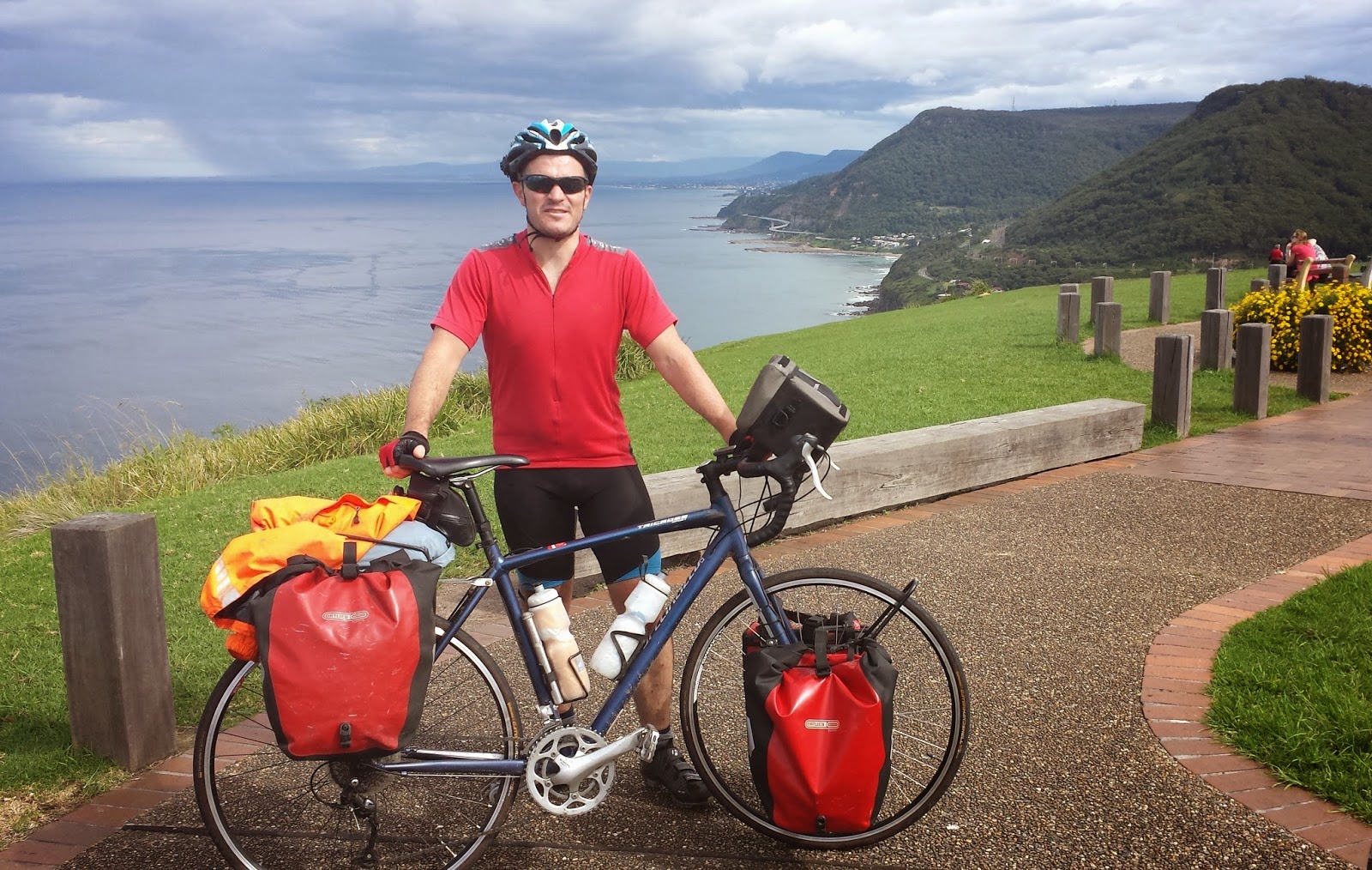
![]() |
| Top of Bald Hill |
At this point the road heads into the national park for another beautiful section of road to ride. But 'Bianca' (my bike) had been playing up. Whenever I was coasting, the chain would catch and try to detach itself...and off and on when pedalling, the forward motion of the pedals was not driving the rear wheel. Bearings I think...and not a problem I can fix. The next town was still 30km away which felt like a very long way...I limped along here pedalling, coasting, and occasionally walking...too busy to take many photos of the beautiful park unfortunately!
Finally at Audley, feeling very hungry and tired, I connected with the Bundeena track and emerged in the southern suburbs of Sydney at Grays Point. A relief to be here, but riding down town was now not an option. I got the bike as far as the Gymea train station...and jumped on board to end the trip somewhat unceremoniously as dusk fell.
This last day felt the toughest on the trip...despite a meer 79 km!! The last 30km was a major slog. It felt a bit of a shame not to ride into the centre of the city...I'd built up a mental picture or riding right to the harbour bridge. But in the end took some satisfaction from at least reaching the suburbs.
What a great trip. Such diversity in scenery, such a massive and beautiful country to explore, and on a bike you see it at what I think is the 'right' pace.
I'll sum up the trip soon and add route maps, helmet cam footage etc when I get back to Melbourne. But for now, its time to enjoy Sydney with my wife!
Distance: 78km
Route map
Thursday, 10 April 2014
Melbourne to Sydney: Day 12
Last night another touring cyclist
arrived at the camp ground who was Sydney based and had loads of
riding experience in this area. He had some great info. The bike
route north into Wollongong could be described as erratic at best,
and Sydney the following day, is a whole new issue. So, it was great
hearing some route ideas from a local.
| 7 Mile Beach & National Park |
It was a wet morning today, and took me
a while to get moving despite being up at 6.30. The first section of
the day was the link road north to the Princess Highway. This was
narrow, no shoulder, and not very nice. Though the Seven Mile Beach
national park it runs through was very nice...and I had a peak at 7
mile beach last night at dusk.
![]() |
| Near Kiama |
From Gerong there were 2 quite big hill climbs, and
then was able to leave the highway at Kiama. From here, in theory you
can take bike paths all the way to Wollongong. I say in theory, as it
would better be described as a discombobulation of tracks, than a
bike path! In some places very well marked, only to suddenly
disappear altogether – which happened often. But in places quite
pretty too as the 'path' follows the coast cliff tops in many places.
![]() |
| Wollongong |
As you get closer to Wollongong, there
is the delight of the industrial zone to get through. The bike path
here is just the pavement, but there is no pedestrian traffic. What a
contrast this was from the last few weeks...
I pulled in to Wollongong around
2pm...it was under 80km but average speed very low with all the
constant map checking and faffing about trying to find the way.
Pretty rubbish day on the bike to be fair...but they cant all be
glamorous eh?
I stayed in doors here and have been
trimming down the gear for the last day...and trying to figure out
how to cycle into downtown Sydney tomorrow.
Distance: 78km
Route map
Distance: 78km
Route map
Tuesday, 8 April 2014
Melbourne to Sydney: Day 11
Today was going to be a bit of a non event for scenery...with no options for looking around without making major detours. I got up early and sourced out breakfast at the slightly bizarre ' Scouse House'.
This delivered everything you'd expect from the title. Thick Scouse 'n proud accents from the staff, a 'greasy spoon' menu..and the place festooned with Scouse paraphernalia; renovated vinyl, football posters etc. Actually the breakfast ended up being a lot better than a greasy spoon feed, thankfully! And the coffee was very good.
Plus, I ate my eggs to the theme of Dead of Alive "You spin me" which seemed appropriate!
Today I wanted to get through the cycle unfriendly town of Nowra as quickly as possible, so rode quite hard in one big push of 85 kms. There was one really rather big hill to get through on the way, but at this point there was a good shoulder and freshly laid bituman so it was quite quick riding. There was a big group of club or charity riders here as well, going the other way complete with escort...we shouted encouragement at one another.
The last few kms into Nowra are grim riding, but I got through this fine without any dramas. I turned off the highway here and pulled over at Shoalhaven heads. Great to stop at lunch time...finally could get these blog posts up as the wifi here WORKS.
2 Days to go...poxy weather on its way.
Distance: 102 km
Route map
Melbourne to Sydney: Day 10
I actually slept pretty well despite
the nightmare, and realised its just the brain processing an event
and not worth dwelling on too much. Nevertheless I'd be as careful as
possible on the Princes Highway today.
First, I had to buy a new phone. Its
ridiculous how dependant you get on these trips on a smart phone. I
had paper maps for longer distance planning which were fine outside
the major urban areas, but loved the nightly chats with my wife
anddidn't fancy approaching Wollongong or Sydney without Google Maps!
So it was a matter of wheeling the
laden 'Bianca' into the Batemans Bay shopping mall, up the disabled
access ramp (as it felt too risky to lock her up outside here). The
whole time I was under the watchful gaze of a security guard who
probably was wondering what the hell the filthy tourist was up too.
He didn't stop me though...I guess my panniers looked far to
conspicuous to try and shoplift with! There were 2 big chain mobile
companies here and the handset prices where ghastly expensive. I
initially decided NO and sat down for breakfast to figure out what
next. On the way out, there was a 'Dick Smith' I'd missed...the
prices were slightly better here though still ghastly. Ruing the
massive expense, and this time getting insurance...I replaced the
phone.
At this point in the trip, if I stayed
only on the highway, it was just under 300kms to Sydney and I had 4
days to do that. My route into town wasn't planned yet but knew I
could ease up on the 100km+ a day thing. I decided to head for
Ulladulla tonight, then try a quick blast through Nowra tomorrow. The
tourers I met in Bermagui had warned me about Nowra and were
sufficiently freaked by the traffic they'd very nearly got a rental
car just for this section...so I was going to treat it with due
respect and at least try and get though fast, at a quiet time of day.
In the meantime, I took a beautiful
detour today down to Murramarang National park and the beach near
South Durras. The down was infested with Kangaroos. Really
infested...one beach house had a whole family on their front lawn,
and in picnic area next to the beach carpark...a large (herd?)were
enjoying the shade. It was nice seeing them up so close as so far I'd
only seen them dead at the roadside, or from a distance.
| Skippy! |
| Murramarang National Park |
| Murramarang National Park |
Heading back to the highway, after my
faffing around this morning looking for a phone, and this detour...it
was suddenly 2pm and I'd barely covered 10km distance towards the
north. I had a strong ride here, doing about 50/60 km in one hit,
with just 1 short stop for a massive piece of carrot cake to keep the
pedals turning. Although it was more highway again today, most of it
was ok with a enough shoulder to keep out of trouble. I forgot about
the alternate route down the old highway here which wouldn't have
lost much time, anyone else doing this route: consider turning off
Princess just north of Durras lake to get off the main road for a
while. Again another cool tip from the folks I met earlier.
The sun was out today and riding
conditions were awesome with little wind, in fact wind has barely
been a factor on this trip. I'll be interested to add up the hills
however...since leaving Bairnsdale there haven't been many flat
sections!
While writing this tonight...this little creature has been constantly trying to sneak up on me to get my dinner. I can't believe how cheeky it is...must have been fed by humans before!
![]() |
| Possum |
Total distance: 81km
Melbourne to Sydney: Day 9
The day started looking like a good one for a ride. Lucky that! Word around the camp ground was that the local Mr Jones coffee shop was the best place in town to kick start your day. So after a small detour to the bakery to fuel up, I meet up there to say goodbye to the couple I'd met last night. They had some great info on the road ahead and it was especially nice to talk to people that 'got' what touring was about.
| Batemans Bay |
Heading north out of Batemans Bay, my first
waypoint of the day was a detour to 'Mystery Bay' – I'd heard a
couple of people say this was a 'must visit'. Its only a small detour
off the Princess Highway and, had it worked into my days better, this
would have been a great place to camp – it had water and a 'long
drop' toilet and nothing else. Also note there is nowhere to get food
near here.
| Mystery Bay |
| Mystery Bay |
As for the bay...its a wild and
beautiful spot. The bay has a golden sand beach with something of a
reef out to sea of jagged rocks. The waves crash in here pretty hard
you'd have to be careful if swimming. There were a few other people
around...but hardly anyone really...just magic.
I spent a while here...but could have
spent the day. Or two.
It was quite late when I left Mystery
Bay so a fairly big afternoon session was on the cards to make my
target for the day. And unfortunately, this also meant a long stint
back on the highway. Near Tuross Head...I was reminded how small and
fragile you are on a bike....
I was crossing a short narrow bridge,
perhaps only 50m long. It was double white line – no passing, and
had no shoulder. Behind me was about 100m or so of straight road –
not a lot, but enough to be seen, so I thought. I was hugging the
left hand white line and heard something big coming up behind me. At
the same time, a ute was coming the other way in the opposite
lane...I just had nowhere to go...but assumed the heavy thing behind
me would slow down. It didn't. Suddenly it flashed by my right
elbow...it felt only a cm or two away and was still accelerating to
clear me before veering hard left into the 80cm or so of sideways
space I had blocked, to not hit the ute. The backblast nearly threw
me and I thought I heard something come off the bike. Veering to a
barely controlled stop at the end of the bride and out the way...I
tried to gather myself. OK check:limbs are still there...yup, I used
them to brake. All the bags were still on the bike...phew. So what
came off? I opened the handle bar bag...the lid was loose. No phone.
Waiting for a gap in the traffic ran back along the bridge and found
it on the road...very smashed. The backwash from the speeding truck
had pulled the Velcro sealed lid open on the bag and sucked out the
phone, but nothing else!!
At least it was just a material
object...it felt like a very close call to me and I tried to fathom
what the driver of the truck was thinking. Maybe be didn't see me
till the last second? I have no clue what company it was and was far
to busy trying not to crash to get the license plate. No choice but
to keep pedalling.
Finally at Moruya I could turn off the
bloody highway, onto the coastal tourist route and ride in relative
peace. It was still 30kms from here and a bit of willpower was needed
to keep going after a long single stint. At an IGA express I grabbed
more water and a large chocolate bar to get me through the last
section. A friendly local saw the loaded bike and came over for chat
which was also nice. I wondered how my friends from this morning
went, on the tricky but pretty hilly section to Tathra.
With weary legs and in a light shower, I arrived at
Surf beach, just south of Batemans Bay and looked for a camp ground
with wifi so I could let my wife know my phone had exploded and not
have her worry if I missed our nightly call. I'd hoped to be able to
update the blog here too and check conditions ahead but the wifi was
so bad all we managed were a few Facebook chat messages.
I had a nightmare that night that the
ute from today was on the other side of the road coming towards me.
Not good!
Total Distance: 120 km
Route map
Route map
Subscribe to:
Posts (Atom)


